Our Fleet of Innovation
Tailored Drone Systems for Every Environmental Challenge

SkyScout Pro
Use this space to promote the business, its products or its services. Help people become familiar with the business and its offerings, creating a sense of connection and trust.

UrbanMapper 360
Use this space to promote the business, its products or its services. Help people become familiar with the business and its offerings, creating a sense of connection and trust.

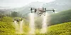
AgriSense X1
Use this space to promote the business, its products or its services. Help people become familiar with the business and its offerings, creating a sense of connection and trust.

EcoGuardian Series
Use this space to promote the business, its products or its services. Help people become familiar with the business and its offerings, creating a sense of connection and trust.
Golf courses are more than just grounds; they're the pulse of the game we love, and we're here to keep yours thriving while saving you water and labor. FlyCRE Golf leverages the extensive project management expertise of Bret Burge, the drone technology prowess of Eric Lynton, and our team's shared passion for golf to provide data-driven solutions that reduce water usage, optimize labor, and maintain exceptional course conditions.


Our Divisions

FlyCRE Solutions
1. Multispectral Imaging for Vine Health
-
Provides detailed plant stress analysis by identifying nutrient deficiencies, disease risk, and water stress before symptoms appear.
-
Helps wineries optimize fertilizer application to improve vine health and grape quality.
-
Enhances early detection of Phylloxera, Powdery Mildew, and other vineyard threats.
FlyCRE Solutions
3. Advanced Soil Sampling & NutrientDeficiency Detection
-
Collects and analyzes soil samples from key vineyard zones to assess salinity, pH levels, and nutrient content.
-
Identifies macro and micronutrient deficiencies to refine fertilization strategies.
-
Recommends custom soil amendment plans to balance nutrients and improve vine health.
FlyCRE Solutions
4. Aerial Spraying for Disease Prevention & Nutrient Optimization
Prevents fungal infections like Powdery Mildew and Botrytis by targeting high-risk zones.
Ensures uniform foliar feeding, maximizing nutrient absorption.
Applies treatments efficiently across large vineyard areas, reducing reliance on manual labor.
FlyCRE Solutions
5. Results for Northern California Wineries
-
Stronger, healthier vines with improved grape consistency.
-
Lower irrigation and pesticide costs through precision application.
-
Faster and more efficient treatments, reducing downtime between applications.
-
Improved soil health, leading to better long-term vineyard productivity.
Northern California Wineries
(Napa Valley, Sonoma, Mendocino, Lake County, Sierra Foothills)
Challenges in Northern California Vineyards
-
Diverse soil compositions (volcanic, alluvial, sedimentary) require different nutrient and irrigation strategies.
-
Fog and microclimates (Sonoma, Russian River Valley) can cause uneven ripening.
-
Varying drainage capacities impact vine health; some areas (volcanic soils) drain too fast, while others (alluvial soils) hold too much moisture.
-
Threat of vine diseases (e.g., Powdery Mildew, Phylloxera) due to high humidity in coastal zones.

FlyCRE’s advanced multispectral imaging, thermal imaging, precision soil sampling, and aerial spraying solutions are designed to revolutionize vineyard management across Northern, Central, and Southern California. By integrating these cutting-edge technologies, FlyCRE enables wineries to optimize irrigation, improve soil health, maximize grape yield, and enhance disease and pest management with unparalleled accuracy.
With multispectral imaging, we provide real-time plant health assessments, allowing for early detection of stress, nutrient deficiencies, and disease. Thermal imaging helps detect water stress and irrigation inefficiencies. Our soil sampling services provide wineries with in-depth salinity, nutrient content, and soil composition data, while aerial spraying solutions ensure precise application of fertilizers, fungicides, and pesticides, reducing labor costs and increasing vineyard efficiency.

FlyCRE Solutions
3. Advanced Soil Sampling & Salinity Management
-
Conducts detailed soil testing to measure salt buildup, organic matter, and nutrient levels.
-
Identifies areas requiring amendments such as gypsum or sulfur to improve soil structure.
-
Provides data for long-term vineyard sustainability and efficient water management.
FlyCRE Solutions
4. Aerial Spraying for Heat & Drought Protection
-
Applies anti-transpirant coatings, helping vines retain moisture and resist heat stress.
-
Delivers foliar nutrients directly to stressed vines, improving grape development.
-
Targets pest control zones to eliminate mites and leafhoppers without chemical overuse.
FlyCRE Solutions
5. Results for Central California Wineries
-
Higher drought resistance and healthier vines.
-
Better soil conditions, improving grape ripening uniformity.
-
Lower pesticide and fertilizer costs, with fewer applications needed.
-
Increased soil sustainability through salinity and erosion management.
Central California Wineries
(Paso Robles, Monterey County, San Luis Obispo, Santa Cruz Mountains, Lodi, Salinas Valley)
Challenges in Central California Vineyards
-
Calcareous and loamy soils retain water differently, leading to inconsistent irrigation needs.
-
Hotter, drier climate (Paso Robles, Lodi) increases risk of heat stress and dehydration.
-
High soil salinity affects vine health and yield potential.
-
Wind erosion (Santa Lucia Highlands) can impact topsoil retention and vine stability.


FlyCRE Solutions
1. Multispectral Imaging for Disease Prevention& Soil Monitoring
-
Provides early detection of Pierce’s Disease, Downy Mildew, and other fungal threats.
-
Tracks nutrient deficiencies in sandy soils, ensuring optimal fertilization.
-
Improves canopy density analysis, optimizing sun exposure and grape development.
FlyCRE Solutions
4. Aerial Spraying for Disease Prevention & Sun Protection
-
Applies targeted pesticide treatments, preventing widespread fungal outbreaks.
-
Delivers precision sunblock coatings to grape clusters, preventing sunburn damage.
-
Ensures optimal coverage on steep terrain, where manual spraying is difficult.
FlyCRE Solutions
5. Results for Southern California Wineries
-
Improved soil fertility and balanced nutrient availability.
-
30–40% water savings by optimizing irrigation.
-
Faster treatment application, reducing disease spread and grape loss.
-
Better grape consistency, improving wine quality and yield.
FlyCRE’s cutting-edge imaging, soil analysis, and aerial spraying solutions provide wineries with the tools to increase vineyard efficiency, enhance sustainability, and produce premium-quality grapes. Let’s build a customized strategy for your vineyard today!
Southern California Wineries
(Paso Robles, Monterey County, San Luis Obispo, Santa Cruz Mountains, Lodi, Salinas Valley)
Challenges in Southern California Vineyards
-
Hot, dry climate demands efficient water management.
-
Granite-based and sandy soils require frequent nutrient monitoring to prevent deficiencies.
-
Fungal diseases (e.g., Pierce’s Disease) are a major concern in warmer climates.
-
Steep terrain vineyards (e.g., Santa Barbara’s Santa Ynez Valley) complicate uniform irrigation and pest control.


Our Divisions
Parks are the heart of the community, and we're here to help keep yours beating strong while maximizing efficiency. FlyCRE Parks combines our team's industry expertise and commitment to excellence to assist park managers in reducing water consumption, saving labor hours, and empowering your team with actionable data. Our insights help you maintain beautiful parks while optimizing resources, ensuring that your community spaces thrive.


Benefits of Multispectral Imaging
Multispectral imaging is an advanced technology that captures image data at specific wavelengths across the electromagnetic spectrum. Unlike traditional photography, which only captures visible light, FlyCRE's multispectral imaging services provide detailed insights by capturing wavelengths beyond the visible spectrum. This comprehensive data enables enhanced detection and precision, making it invaluable across various industries.

Enhanced Detection
Identifies features invisible to the naked eye.

Precision
Provides detailed data for targeted interventions.

Efficiency
Covers large areas quickly, saving time and resources.

How Multispectral Imaging Works
We deploy drones equipped with multispectral sensors that capture images at different wavelengths as they fly over an area. These images are processed and layered to create actionable data for analysis. Our sensors are meticulously calibrated before each flight to ensure consistent and accurate data quality.
Multispectral Data
Multispectral cameras capture light reflectance at specific electromagnetic wavelengths, providing crucial information for analyzing vegetation health, soil properties, water quality, and material composition. Indices such as the Normalized Difference Vegetation Index (NDVI) are derived from this data to offer actionable insights.
Multispectral Technologies
Our drones are equipped with multispectral sensors, including high-resolution cameras with 3-5 lenses, each calibrated to different wavelengths. After capturing the data we use our advanced software to process and analyze the data.

Types of Multispectral Data Captured
Our multispectral imaging captures data across various wavelengths, providing valuable insights:
Visible Spectrum (RGB)
Standard color images that show what the human eye can see. Useful for general visualization and mapping.
Near-Infrared (NIR)
Captures light just beyond the visible spectrum. NIR imaging reveals details about vegetation health, water content, and plant stress that aren't visible in standard images.
Red Edge
A narrow band between visible red light and near-infrared. It's sensitive to chlorophyll content, helping assess plant vitality and detect diseases early.
Thermal Infrared
Measures temperature differences across surfaces. Useful for detecting irrigation issues, soil moisture levels, and identifying areas of heat loss or gain.
UltraViolet (UV)
Captures wavelengths shorter than visible light. UV imaging highlights specific material properties and can detect certain biological markers.
By analyzing this data, we derive indices like the Normalized Difference Vegetation Index (NDVI) and other specialized metrics. These insights help you make informed decisions and take targeted actions.
Use Cases For Multispectral Imaging

Turf Management
-
Golf Courses and Sports Complexes
-
Revolutionize Turf Management: Obtain precise data on grass health, soil conditions, and irrigation efficiency.
-
Optimize Maintenance: Identify stress areas, detect diseases early, and manage resources efficiently.
-
Enhance Player Experience: Maintain high-quality playing surfaces for better playability and satisfaction.
-
-
Parks and Recreation
-
Sustainable Landscaping: Monitor vegetation health to maintain vibrant public spaces while optimizing resource use.
-
Disease Detection: Early identification of plant diseases helps in timely interventions.
-

Agriculture
-
Optimize Crop Management: Monitor vegetation health, detect diseases early, and improve resource efficiency.
-
Enhance Yield: Make informed decisions on irrigation, fertilization, and pest control to maximize productivity.

Environmental Monitoring
-
Track Ecosystem Health: Monitor biodiversity and assess environmental impacts.
-
Conservation Efforts: Provide data to support habitat preservation and restoration projects.

Urban Planning
-
Evaluate Urban Green Spaces: Assess the health of vegetation in urban areas.
-
Detect Heat Islands: Identify areas with higher temperatures due to urbanization.
-
Infrastructure Monitoring: Monitor conditions of infrastructure and plan for sustainable development.
Transparent Reporting for Stakeholders
FlyCRE’s platform simplifies communication with stakeholders. Add users such as owners, board members, and greens committees to access detailed reports, enabling data-driven decisions for maintenance plans and budgets.
Custom Solutions
Need a custom solution? Contact us to discuss how we can customize our services to meet your specific requirements.

